

South America
South America
Chanaral Island Cruise Port Guide: What to Expect & Getting Around
Chile
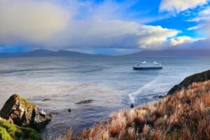
Ships anchor offshore; tender boats required to reach shore.
Choose the Right Port Day
Best Overall
Join the cruise line's included naturalist talk or bird-focused shore excursion; the guides identify species and geological features you'd miss alone.
Best Beach
Not a beach destination. Chanaral Island's shoreline is rocky and windswept; suited to geological observation, not swimming or sunbathing.
With Kids
A guided naturalist walk (ask your cruise director) focusing on seabird colonies and desert ecology is usually more engaging than unstructured wandering. Keep sun protection and water at hand.
Only 3-4 Hours
Take the tender ashore, walk the immediate desert perimeter or beach strand for birdwatching and rock formations, return to ship. No transport needed; the landscape is the activity.
Cheapest Option
Tender ashore (often complimentary or minimal fee via ship) and explore independently. Cost ~$0–15 USD if no excursion package is booked.
What To Avoid
Do not wander far inland without a guide or clear landmark references; terrain is featureless and disorienting. Avoid midday sun exposure without adequate cover and water.
Top Things To Do
1
Naturalist-guided shore walk
Join the cruise line's included or optional naturalist excursion. Guides identify seabirds (Humboldt penguins, cormorants, gulls), discuss Atacama Desert geology, and explain the island's ecological significance. Typically covers 2–3 km on open terrain.
2
Independent desert and shoreline exploration
Walk the immediate area around the landing beach or rocky point. Observe seabirds, examine rock formations, and photograph the stark Atacama landscape. Safe range is typically within 1–2 km of the landing.
3
Seabird and wildlife observation
Chanaral Island is a breeding site for Humboldt penguins and various seabirds. Patient observation—especially with binoculars—rewards birdwatchers. Best done with a guide or as part of a cruise excursion.
Book with the ship, or on your own?
Booking independently
- Often noticeably cheaper than the ship’s version of the same tour.
- Smaller groups and local operators, with traveler reviews you can read before you pay.
- Free cancellation on most tours, usually up to 24 hours before.
When the ship’s excursion makes sense
- Short port calls or long transfers where the timing is tight.
- Tender-only stops where getting ashore can run late.
- The ship waits for its own delayed excursions — it won’t wait for independent ones, so leave a buffer before all-aboard.
We may earn a commission when you book through our links, at no extra cost to you — it’s how we keep these guides free.
Quick Take
- Port Type
- Remote desert anchorage.
- Best For
- Expedition-cruise passengers; desert/wildlife photography; geology and natural history interests.
- Avoid If
- You want nightlife, dining variety, shopping, or beach relaxation.
- Walkability
- Port has no formal town; tender-dependent. Nearby desert is accessible but exposed; not pedestrian-friendly for extended roaming.
- Budget Fit
- Low-cost; most shore time is naturalistic or self-guided. Optional excursions (birding, geology) vary by cruise line.
- Good For Short Calls?
- Yes; 4–5 hours is realistic for desert walks or wildlife spotting.
Port Overview
Chanaral Island lies off the northern Chilean coast in the Atacama Desert region. Ships anchor offshore; no formal port infrastructure exists. A tender ferries passengers to a small beach or rocky landing. The port's appeal is geological and ecological: stark desert vistas, seabird colonies (including Humboldt penguins), and a sense of isolation. Expedition cruise lines (Ponant, Lindblad, Hurtigruten, Silversea) use it as a landing for naturalist activities, not general tourism. There are no shops, restaurants, or typical shore facilities. Ashore time is usually 4–6 hours, most spent on guided walks or independent exploration of the immediate desert fringe.
Is It Safe?
Chanaral Island is isolated but generally safe. The main hazard is the environment: intense sun, wind, sparse shade, and rugged terrain. Dehydration and exposure are real risks on longer walks. The desert can appear featureless and disorienting; do not stray far from your landing point or guide without clear landmarks. Tenders are the only transport; sea conditions can affect schedules. No medical facilities exist ashore; serious illness or injury requires evacuation. The area is sparsely populated, but cruise-line groups are monitored and structured, reducing risk. Follow your cruise director's safety briefing and stay alert to changing weather.
Accessibility & Walkability
Chanaral Island is not wheelchair-accessible. The tender process involves climbing into small boats (risky for mobility-limited passengers), and the shore is rocky, uneven terrain with no paved paths or ramps. Passengers with limited mobility should consult the ship's accessibility office before the port. Independent wandering is unsafe for those with balance, vision, or endurance issues. If you book an excursion, inform staff of mobility constraints; some guides can offer modified shorter walks or observation points closer to the landing.
Outside the Terminal
There is no terminal. Upon tender arrival at the beach or rocky shore, you step directly onto sand or rock. The immediate surroundings are open desert: low scrub, rock outcrops, and wind. The air is dry and often windy. The only infrastructure is a temporary landing area and, depending on the cruise line, a gazebo or shade structure for regrouping. Within the first 10 minutes, you are either meeting your naturalist guide (if on an excursion) or choosing your own direction for a walk. The sense is one of immediate exposure to wilderness—no shops, no people, just landscape.
Beaches Near the Port
Chanaral Island beach landing zone
Small sandy or rocky beach where tenders arrive. Not a swimming or sunbathing destination; used for landing and departure only. Rocky sections offer geological interest and occasional tide pools.
Local Food & Drink
There are no restaurants or food vendors at Chanaral Island. All meals are on your cruise ship. If planning a full day ashore, pack snacks and water from the ship (or ask the crew to prepare a packed lunch). The sun and wind accelerate dehydration; bring at least 1–2 liters of water per person. Eating ashore is not an option; plan accordingly.
Shopping
There is no shopping at Chanaral Island. No stores, stalls, or markets exist. If you wish to purchase souvenirs, postcards, or gifts related to Chilean natural history or the Atacama, do so at larger ports (Caldera, Antofagasta, or ports later in your cruise). Some cruise lines sell expedition-themed merchandise onboard.
Money & Currency
- Currency
- Chilean Peso (CLP)
- USD Accepted?
- No
- Card Payments
- N/A; no merchants ashore.
- ATMs
- None.
- Tipping
- N/A for this port.
- Notes
- No currency exchange or financial services exist at Chanaral Island. Bring any cash you need for other ports from your home country or exchange at a larger Chilean port.
Weather & Best Time
- Best months
- October–April (spring/summer in Southern Hemisphere); mild to warm, lower wind.
- Avoid
- July–August (winter); cooler, windier, higher seas may hamper tender ops.
- Temperature
- Most expeditions visit October–March; daytime 18–28°C (64–82°F). Wind and low humidity are constant.
- Notes
- The Atacama is one of Earth's driest places. Rain is extremely rare. Sun exposure and wind dehydration are year-round concerns. Bring high-SPF sunscreen, a hat, and layers (wind can feel cold despite sunshine). Seas can be rough; tender operations may be delayed or cancelled.
Airport Information
- Airport
- Caldera Airport (CLD) or Antofagasta International (ANF)
- Distance
- Caldera ~80 km south; Antofagasta ~400 km north.
- Getting there
- Most passengers embark/disembark via these airports as part of cruise itinerary. Cruise lines arrange transfers. Independent travel is possible but uncommon.
- Notes
- Chanaral is not a typical start/end port. Confirm your cruise itinerary's home port and transfer logistics with your cruise line well in advance.
Getting Around from the Port
Tender from ship to shore
Ships anchor offshore; tenders (Zodiacs or small boats) transport passengers to a designated beach or rocky landing point. Expect a 10–20 minute ride depending on sea state and anchoring position.
Walking ashore
Once landed, most exploration is on foot across open desert or along the rocky shoreline. No roads, vehicles, or marked trails.
Cruise-line naturalist excursion
Most expeditions include a guided shore walk with a naturalist, geologist, or birding specialist. These are curated and time-managed by the ship.
Details last checked April 2026
Check The Port Traffic
Cruise Ships in Port
Once you have your shore plan, use the schedule to see how busy the harbour will be on your date, plus the ships, lines, and published call windows.
Sun
Mon
Tue
Wed
Thu
Fri
Sat
1
2
3
4
5
6
7
8
9
10
11
12
13
14
15
16
17
18
19
20
21
22
23
24
25
26
27
28
29
30
Quiet (1–2)
Busy (3–4)
Packed (5+)
0 scheduled calls
July 31, 2026
No scheduled cruise ship calls were found for this date selection. Pick a highlighted day on the calendar above, widen the range, or search for a different ship or line.
Planning a cruise here?
Ponant, Lindblad Expeditions, Hurtigruten & more sail to Chanaral Island.
Practical Tips for Cruise Passengers
- Bring and drink plenty of water; the Atacama is extremely dry and windy, and dehydration happens fast even on cool days.
- Wear robust hiking boots or sturdy shoes with good grip; rocky, uneven terrain is the norm ashore.
- Apply high-SPF sunscreen (50+) and wear a wide-brimmed hat and UV-blocking clothing; reflection off rock and sand intensifies sun exposure.
- Join the naturalist excursion if available; guides reveal wildlife, geology, and ecological details you would likely miss alone.
Frequently Asked Questions
Not recommended. The water is cold (Pacific, ~15–18°C / 59–64°F), rocky-bottomed, and often rough. The landing zones are functional, not recreational beaches.
Tenders may be delayed or cancelled if waves exceed safe limits. The ship will monitor conditions and inform passengers. Missed ashore time is typically not refundable, but flexibility is built into expedition itineraries.
No. There is no permanent settlement or infrastructure at Chanaral Island. All food, supplies, and shopping must be arranged through your ship or at other ports in your itinerary.
Find cruises to Chanaral Island, Chile
Compare sailings and book with no fees — best price guaranteed.
We may earn a commission when you book through our links, at no extra cost to you — it’s how we keep these guides free.
✉ Sailing to Chanaral Island? Get your port-day plan
Tell us your sail date and we’ll email you a short Chanaral Island plan about 60 days out — when the good excursions start selling out — plus a final checklist 2 weeks before. Two emails, then done. Unsubscribe anytime.
South America
View All
More South America Ports

South America
South America

South America
