

South America
South America
Isla de los Estados Cruise Port Guide: Getting Around & What to Expect
Argentina
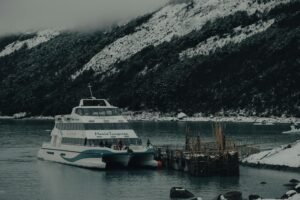
Ships anchor offshore; tender boats required to reach the island.
Choose the Right Port Day
Best Overall
Guided naturalist-led tender landing with wildlife interpretation; this is the core reason for calling here.
Best Beach
Not a beach destination; shorelines are rocky and wildlife-focused. Estancia Bay offers scenic anchorage and coastal views.
With Kids
Ranger-led wildlife spotting via tender from safe distance; seal and bird colonies visible without hiking. Age/ability limits apply; verify with cruise line.
Only 3-4 Hours
Tender ashore for guided wildlife walk near landing site (Fuerte Paz or Estancia Bay), focusing on sea lion colonies and sub-Antarctic flora; return to ship for lunch.
Cheapest Option
Landings are expedition-cruise inclusive; no independent cheap options exist. Tender rides and guide services are pre-paid.
What To Avoid
Do not expect shops, restaurants, or services ashore; all provisions and activity are ship-based. Weather often cancels landings; flexibility is essential.
Quick Take
- Port Type
- Remote expedition anchorage
- Best For
- Expedition cruisers seeking remote landscapes, Cape Horn proximity, and wildlife viewing without crowds.
- Avoid If
- You need infrastructure, retail shopping, or easy city exploration; poor weather windows or sea conditions may cancel landings entirely.
- Walkability
- Not applicable; landings are small-group tender-based in designated areas only.
- Budget Fit
- High—excursions and activities are included on expedition cruises; independent day-trippers rare.
- Good For Short Calls?
- Excellent; most landings and wildlife outings run 3–4 hours via tender.
Port Overview
Isla de los Estados sits at the southern tip of Argentina, east of Cape Horn, and is accessible only by expedition cruise ship anchoring offshore. Ships tender small groups ashore to designated landing sites on a weather-dependent basis. There are no port facilities, town, or commercial infrastructure—only a handful of historic ruins, ranger stations, and protected wildlife habitat. Cruisers visit exclusively for remote landscape photography, sea lion and penguin colonies, and sub-Antarctic natural history. This is not a leisure or shopping port; it is a destination for expedition-cruise passengers who accept weather cancellations and value solitude and wildlife access over comfort.
Top Things To Do
1
Guided wildlife and naturalist landing
Shore excursion led by expedition naturalist. Focus on sea lion colonies, Magellanic penguins, cormorants, and Fuegian sub-Antarctic plant life. Stops include Fuerte Paz ruins or Estancia Bay. Photography and binocular observation are primary activities.
2
Historic ruins exploration (Fuerte Paz)
Walk through remains of 18th-century Spanish settlement. Minimal interpretation onsite; naturalist provides context. Low-key historical site with scenic overlooks.
Book with the ship, or on your own?
Booking independently
- Often noticeably cheaper than the ship’s version of the same tour.
- Smaller groups and local operators, with traveler reviews you can read before you pay.
- Free cancellation on most tours, usually up to 24 hours before.
When the ship’s excursion makes sense
- Short port calls or long transfers where the timing is tight.
- Tender-only stops where getting ashore can run late.
- The ship waits for its own delayed excursions — it won’t wait for independent ones, so leave a buffer before all-aboard.
We may earn a commission when you book through our links, at no extra cost to you — it’s how we keep these guides free.
Is It Safe?
Isla de los Estados is remote and weather-exposed; seas can be rough and conditions unpredictable. All landings require crew approval and are subject to cancellation. There is no medical facility ashore; ship's doctor is the only resource. Wildlife (sea lions, birds) must be viewed from safe distances; do not approach or touch. There is no crime risk in the traditional sense, but disorientation, cold exposure, or slip hazards are real. Follow ranger instructions without exception.
Accessibility & Walkability
This port is not wheelchair or mobility-accessible. Tender boarding involves climbing nets, stepping into small boats, and jumping onto rocky beaches. Terrain ashore is uneven, muddy, and hazardous in wind. If you have limited mobility, inform the cruise line pre-sail; landings may not be possible. No paved paths, ramps, or assistance infrastructure exist.
Outside the Terminal
There is no terminal. Ships anchor offshore in open water. Tender boarding occurs at the ship's gangway or platform. Once ashore, you arrive at a small beach or rock landing with no facilities, signage, or amenities—only the landscape, wildlife, and a ranger or guide. The experience is intentionally raw and unmediated.
Local Food & Drink
There are no restaurants, cafés, or food vendors ashore. All meals are onboard the ship. Bring water and snacks if permitted. Expedition cruises provide gourmet, multi-course dining; meal timing is coordinated with landing schedules.
Shopping
There is no shopping of any kind. No gift shops, markets, or souvenir stands exist. Bring any personal items or provisions from home or larger ports earlier in the itinerary.
Money & Currency
- Currency
- Argentine Peso (ARS)
- USD Accepted?
- No
- Card Payments
- Not applicable; no businesses or vendors ashore
- ATMs
- None
- Tipping
- Not applicable; tips are settled onboard
- Notes
- Currency is irrelevant at this port. All transactions occur onboard in USD or cruise line shipboard account.
Weather & Best Time
- Best months
- November–March (austral summer)
- Avoid
- April–October (cold, snow, extreme weather)
- Temperature
- 5–12 °C (41–54 °F), often wet and windy
- Notes
- Summer visits still experience fog, rain, and rough seas. Weather cancellations are common. Pack waterproof layers, windproof outer shell, and insulated gloves. Sunscreen and bug spray rarely needed; focus on cold-weather protection instead.
Airport Information
- Airport
- Ushuaia International Airport (Aeroparque Jorge Newbery alternative connection)
- Distance
- Isla de los Estados is 150+ km east of Ushuaia; no direct transport
- Getting there
- Cruise embarkation/disembarkation is in Ushuaia. Fly into Ushuaia, board ship there. No ferry or air service from island.
- Notes
- Isla de los Estados is not an embarkation port. Ships call en route to/from Cape Horn itineraries. All airport logistics use Ushuaia as the gateway.
Getting Around from the Port
Ship tender (zodiac/small boat)
Only transport to shore; operated by cruise line staff. Landings occur at designated sites (Fuerte Paz ruins, Estancia Bay, or similar) depending on weather and environmental conditions.
Book ferry ticketsWalking ashore (guided)
All ashore activity is ranger or naturalist-led within restricted zones. No independent roaming; groups stay together for safety and environmental protection.
Details last checked April 2026
Check The Port Traffic
Cruise Ships in Port
Once you have your shore plan, use the schedule to see how busy the harbour will be on your date, plus the ships, lines, and published call windows.
Sun
Mon
Tue
Wed
Thu
Fri
Sat
1
2
3
4
5
6
7
8
9
10
11
12
13
14
15
16
17
18
19
20
21
22
23
24
25
26
27
28
29
30
31
Quiet (1–2)
Busy (3–4)
Packed (5+)
0 scheduled calls
August 18, 2026
No scheduled cruise ship calls were found for this date selection. Pick a highlighted day on the calendar above, widen the range, or search for a different ship or line.
Planning a cruise here?
Lindblad Expeditions, Hurtigruten, Quark Expeditions & more sail to Isla de los Estados.
Practical Tips for Cruise Passengers
- Confirm landing probability with your expedition crew before sailing; weather windows are narrow and forecasts change daily. Pack accordingly and stay flexible.
- Bring high-quality waterproof binoculars, a sturdy camera, and extra batteries; this is a photographer's destination and conditions are harsh on gear.
- Wear multiple layers and a wind-resistant outer shell even in summer; wind-chill at the southern tip is severe and weather shifts in minutes.
- Do not attempt independent exploration beyond ranger-approved zones; terrain is unstable, wildlife is protected, and rescue is complicated.
Frequently Asked Questions
No. Weather, sea state, and environmental conditions often force cancellations. Expedition itineraries include Isla de los Estados as a planned stop, but landings are never guaranteed. Accept this uncertainty as part of the experience.
All ashore activity is ranger or naturalist-led in small groups. Independent roaming is prohibited for safety and environmental protection. You must stay with your assigned group at all times.
No. There are no restaurants, shops, or services. All food and provisions are onboard your ship. Plan accordingly and do not expect to supplement meals ashore.
Find cruises to Isla de los Estados, Argentina
Compare sailings and book with no fees — best price guaranteed.
We may earn a commission when you book through our links, at no extra cost to you — it’s how we keep these guides free.
✉ Sailing to Isla de los Estados? Get your port-day plan
Tell us your sail date and we’ll email you a short Isla de los Estados plan about 60 days out — when the good excursions start selling out — plus a final checklist 2 weeks before. Two emails, then done. We’ll send one note to confirm it’s really you — unsubscribe anytime.
South America
View All
More South America Ports
South America

South America

South America
